
Core Civil Engineering Services in Modern Site Development
Whether a project involves a small residential renovation or the master planning of a sprawling commercial district, the foundation of every successful development lies in accurate data. Precision at the start of a project prevents costly delays, legal disputes, and structural errors that can derail progress during the construction phase. By integrating land surveying early into the planning process, developers and property owners can gain a comprehensive understanding of their site’s constraints and potential.
Effective site development requires more than just a measurement of property lines; it demands a synergy between spatial mapping and civil engineering. When these disciplines work in tandem, the resulting data informs every decision from earthwork and utility placement to municipal permitting and environmental compliance.
For those navigating the complexities of land development, understanding how to select an integrated civil engineering firm is a critical first step. This guide explores the essential services, technologies, and professional standards that turn raw land into resilient, functional community infrastructure.
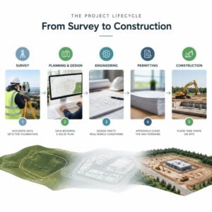
Modern site development is a multidisciplinary effort. It encompasses site grading, utility design, and complex stormwater management, all of which must align with local municipal permitting and regulatory requirements. A land survey company acts as the primary data provider for these efforts, ensuring that engineers are working with a digital twin of the site rather than outdated or inaccurate records.
When a project team utilizes an integrated approach, the land surveying data flows directly into the engineering design software. This reduces the risk of “data silos” where the surveyor and the engineer are working from different sets of assumptions. By aligning the survey deliverables with the specific needs of the civil engineering team, projects can move from feasibility to groundbreaking with significantly less friction.
Front-End Civil Engineering Services and Feasibility Analysis
Before a single shovel hits the dirt, a deep dive into the site’s history and physical characteristics is required. Front-end services focus on risk mitigation and feasibility. This includes detailed deed research to establish legal ownership and encumbrances, as well as the creation of high-fidelity topographic maps.
Engineers look for environmental constraints, such as wetlands or steep slopes, and perform zoning analysis to ensure the proposed development aligns with local ordinances. Identifying these factors early allows the design team to adjust site plans before expensive engineering hours are wasted on designs that cannot be permitted.
Construction Layout and As-Built Civil Engineering Services
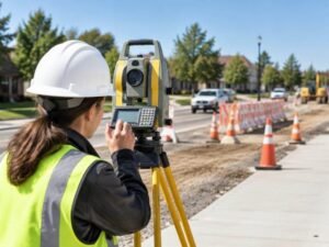
Once the design is finalized, the focus shifts to construction layout. This is the process of translating engineering plans into physical markers on the ground. Surveyors use high-precision tools to stake out building corners, road centerlines, and utility invert elevations, ensuring that the construction team builds exactly what was designed.
As the project nears completion, as-built documentation becomes vital. These surveys capture the final location of all improvements, including underground utilities, to ensure they match the approved plans. This documentation is not just a bureaucratic requirement; it serves as a permanent record for future maintenance, insurance, and potential property sales.
Comparing Essential Land Surveys in Community Infrastructure
Understanding the differences between common survey types is essential for project planning. Each serves a distinct purpose in the development lifecycle.
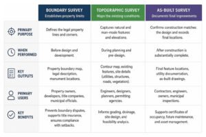
- Boundary Surveys: These are legal documents that establish the precise perimeter of a property. They are essential for resolving boundary disputes, securing title insurance, and ensuring that new structures do not encroach on neighboring land.
- Topographic Surveys: These provide the “lay of the land,” mapping both natural features like trees and elevation contours, as well as man-made features like curbs, fences, and existing structures. They are the primary tool for grading and drainage design.
- As-Built Surveys: Performed after construction, these confirm that the project was built according to the design specifications. They are critical for obtaining certificates of occupancy and managing long-term asset records.
Advanced Geospatial and Subsurface Technologies in Civil Projects
The surveying profession has evolved far beyond the traditional transit and tripod. Today, land survey companies utilize a suite of advanced technologies that increase speed and accuracy while reducing human error.
LiDAR and Aerial Mapping
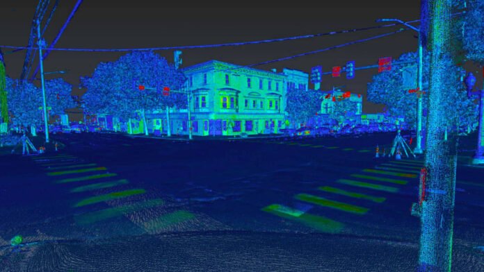
Aerial drones equipped with LiDAR (Light Detection and Ranging) sensors can scan large tracts of land in a fraction of the time required by ground crews. This technology generates dense point clouds that allow engineers to create highly accurate digital elevation models. These models are particularly useful for large-scale developments where identifying subtle changes in terrain is necessary for effective stormwater management.
Subsurface Utility Locating
One of the most significant risks in any excavation project is striking an underground utility. Modern firms now integrate subsurface utility engineering (SUE) into their workflows. This involves:
- 811 Ticket Management: Coordinating with public utility providers to mark existing lines.
- Private Utility Locating: Using ground-penetrating radar and electromagnetic induction to map private lines that standard public services might miss.
- Damage Prevention Protocols: Implementing rigorous training and verification steps to ensure that field crews are fully aware of what lies beneath the surface before breaking ground.

Frequently Asked Questions About Land Development
Why are front-end site surveys critical before excavation?
Front-end surveys are the “insurance policy” of a construction project. By accurately defining the site geometry and identifying potential obstacles early, developers can avoid the “stop-work” scenarios that occur when a contractor discovers an unexpected utility line or a property line encroachment during the middle of a build.
How do municipal zoning and FEMA flood zones impact site planning?
Zoning laws dictate what can be built and where, while FEMA flood zone requirements dictate how high a structure must be raised to mitigate flood risk. A professional land survey company provides the base elevation data necessary to demonstrate compliance with these regulations, which is a prerequisite for obtaining building permits and securing flood insurance.
What is the role of a licensed surveyor in engineering deliverables?
A licensed Professional Surveyor and Mapper (PSM) or Professional Land Surveyor (PLS) is legally responsible for the accuracy of the survey. Their seal on a document signifies that the survey meets state-mandated standards of practice. This certification provides the legal defensibility required for property transactions and municipal approvals, ensuring that the data used for engineering is reliable and accurate.
Conclusion
The successful development of community infrastructure is a testament to the power of precision data. By prioritizing high-quality land surveying and integrating it with modern engineering practices, developers can create projects that are not only durable and functional but also resilient to the challenges of the future.
Whether it is through the use of aerial LiDAR or the meticulous research of historical deeds, the goal remains the same: to provide a clear, accurate, and legal foundation upon which a community can grow. As technology continues to advance, the partnership between surveyors and engineers will remain the cornerstone of responsible and efficient land development.